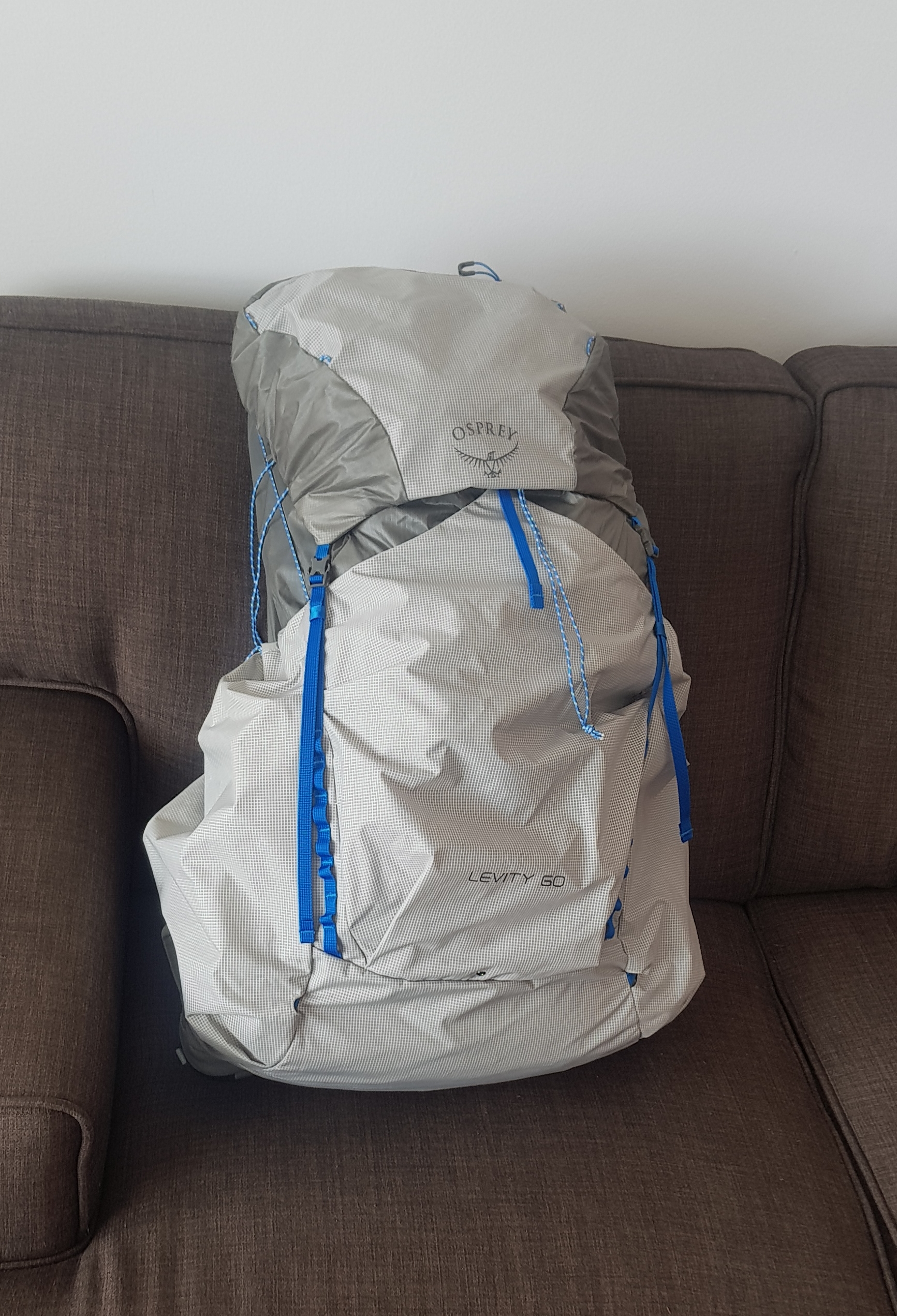
With exactly a month to go before I start, I realised I haven’t actually done any “training” yet. I always walk a lot, but I’ve never carried a full pack for very long before. I bought the Osprey Levity 60 pack two weeks ago when I was in Melbourne and carried it around Melbourne for a few hours with a 6kg or so weight, but I thought I better start walking on weekends with it fully loaded.
So yesterday rolled around, and since it was a nice Saturday with little rain forecast I piled a lot of cans and other things into the pack to make the load 11.3kg, and went out for a walk.
I live close to Mount Eden and that was my first stop – to walk up to the top of there. My calves were burning as I was walking up the hill but the pack itself felt good. I kept trying to pull the bottom of the pack down, but I think that’s because it’s a smaller pack than I’m used to carrying. I spent quite a while with the salesman in Paddy Pallin getting it fitted and learning about it, and also I got the Large version of the pack so there was nothing longer.
I’ve never had a bag that sits away from your back before. It was weird but very nice to finish the walk without a sweaty back! However it did mean I wasn’t used to the way the pack sat on my back – I could feel the things in the top of the pack on my shoulders and the things at the bottom but not the things in the middle obviously.
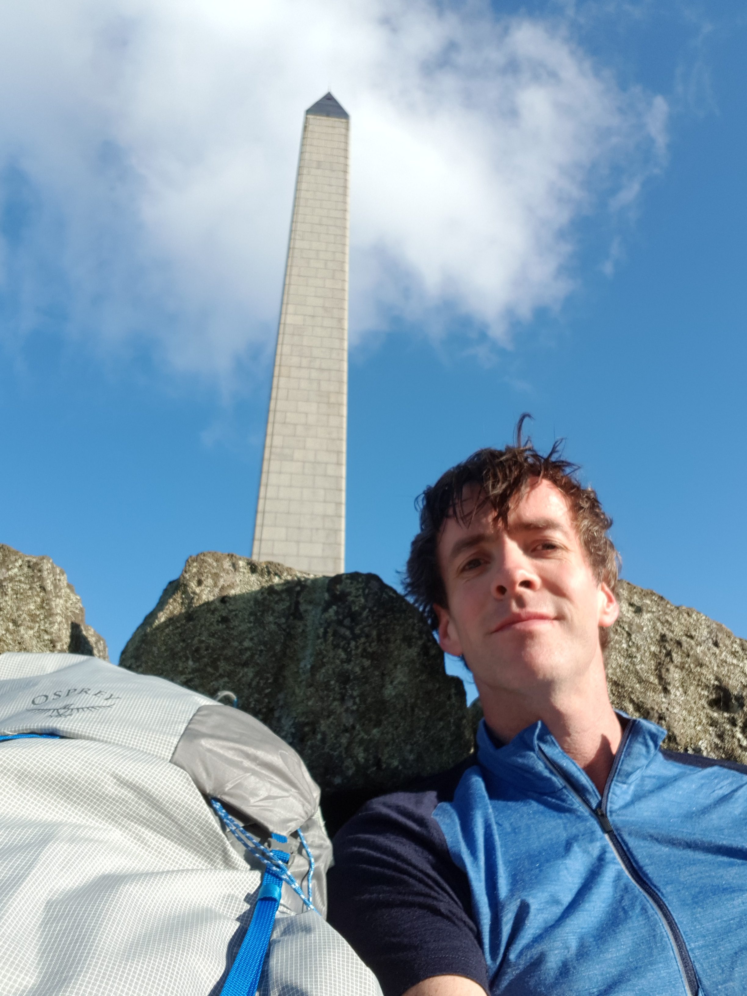
I was also trying to follow the trail route to test out my mapping app. So the next stop was Cornwall Park and One Tree Hill. This is where I noticed something interesting. The trail notes for the Coast to Coast Walkway (this section) say that you have to walk “up to One Tree Hill summit”, however every map I have seen shows the trail going around the edge of the park and completely bypassing the summit. The perfectionist in me was uncomfortable about this. Do I have to walk up to the summit or don’t I? I would hate to tell people in the future that I walked Te Araroa, and they say to me “cool! How did you like the summit of One Tree Hill?” and I’d say “actually I didn’t do that bit” and they’d say “hmmmmmmmmmm…..”
The council website for the walkway shows the path going to the summit. And you go to the summit of Mount Eden, so why not One Tree Hill?
I’m not going to pester the TA Trust about this sort of little thing though. They do a great job providing the trail route in different formats and all the trail notes. Well, maybe after I’ve given them my donation I might ask them 🤣 🤣
I did end up walking up to the summit on this occasion and I took a photo from the top. I was going to ask a tourist to take a photo of me and the pack and the obelisk all in the same picture, but I think it would have been unfair to get them to frame the photo exactly how I would want it. so I settled for a selfie 😁 I won’t post any pictures of the view from the top, because as a local I’ve seen the view a hundred times! But there are a selection of other photos that I took yesterday below.
At the summit it was very windy and the wind was very cold. But yet I couldn’t be bothered taking the pack off my back to get out my wind jacket. Not because it was heavy or awkward, but because the only access into the pack is via the top and I’d have to take everything out in order to find the jacket. Clearly the way that you arrange things in the pack is going to be important. Besides, I thought, I can handle the cold, the cold doesn’t affect me. So I just kept walking with my merino shirt and my shorts. Even when a few spits of rain started, I didn’t stop and take my waterproof pack liner out of the pack, again because I couldn’t be bothered, but also because the rain was just a few spots.
I really should have taken the time to find my jacket. I was cold to the bone once I got home. I turned the heater on and sat under it for a couple of hours. But it makes me glad that on the trail I’m taking a wind jacket, a rain jacket, thermals, and two shirts.
One thing I noticed about the pack is that the inner layer of nylon is very thin – to be expected for such a lightweight pack I suppose. I’m going to have to be very careful about spiky or sharp things inside the pack piercing the fabric. Which is okay, because I plan to keep everything inside in a rubbish bag or a dry sack anyway.
I’m not going to write a full-on proper review of the pack until I’ve been walking with it for a while. But my walk today was decent, it was 14km and I only had a very slight twinge of back pain after the 14km which went away after I took the pack off. This is why I’m doing these walks – to prepare myself for walking with a pack like this every day.
This time one month from now I will be on the bus to Kaitaia!


Hi Matt….. The trail officially skirts around One Tree Hill but most hikers will detour up, so best advice is to go up.
The trail also goes through the middle of the University and can be a bit confusing so maybe check that out beforehand, as well the trail goes across Auckland Domain and when we went through, there were a number of cricket games going on (weekend) and we had to deviate around those which were taking place on the official trail.
We have a day by day account on Instagram @hiking_aotearoa and would be happy to answer any questions you may have…… we start back on the trail end of Nov at the start of the Timber Trail….. all the best for your Hike.
Thanks for the information! That’s what I assumed it was just the one little bit in the notes that referred to the One Tree Hill summit so I wonder if that was just copied and pasted from the council website.
Once I set up my new Instagram account for the hike I’ll make sure I follow you! And if you’re starting in late November at Timber Trail there’s a high chance I’ll come across you at some point!
Brace yourself for more shenanigans like that summit issue along Te Araroa! There are a few official sources of navigation (notes, maps, trail status page, and ground conditions) and you will have moments along the trail where those sources deviate or disagree on what the correct route is.
Take a fluid approach (like you did up Maungakiekie) and you’ll be right.